

The Road Through the Mountain
- Bhalchandra Chorghade

- Jun 6
- 8 min read
While the Mumbai–Pune Missing Link project will cut travel time, its real story lies in the tunnels and engineering ingenuity that overcame one of India’s most challenging landscapes

For most motorists, the Mumbai–Pune Expressway is one of modern India’s great infrastructure success stories. Since opening in 2002, it has dramatically reduced travel time between Maharashtra’s political and financial capitals while becoming a critical artery for industry, logistics and commerce.
Yet buried within that success was a persistent weakness. One stretch of the route through the steep Sahyadri ghats has continued to generate a disproportionate share of congestion, delays and accidents. Over time, what appeared to be a localised engineering challenge has evolved into a much larger question: how does one build reliable mobility through one of India’s most difficult landscapes?
The answer eventually became the Missing Link project. According to Rajesh Patil, Joint Managing Director of the Maharashtra State Road Development Corporation (MSRDC), officials gradually realised that the existing ghat section had become a major operational bottleneck.
“Initially, we realised that the ghat section was becoming a major bottleneck. Especially while approaching Pune, the steep gradients created a difficult situation,” he recalls.
Detailed traffic studies produced a revealing finding. Although the problematic stretch represented only a small segment of the corridor, a majority of recurring traffic disruptions originated there.
“During our detailed study, we observed that congestion patterns were concentrated within a particular stretch of a few kilometres. Around 60 to 70 percent of the traffic problem was happening in that section itself,” said Patil.
The issue was not simply traffic volume but the interaction between vehicles and terrain. Motorists climbing towards Pune encountered steep gradients that slowed traffic and created bottlenecks while vehicles descending the ghats faced a different challenge altogether. Heavy trucks often gathered excessive speed while negotiating long downhill stretches, forcing authorities to intervene regularly.
“The police would often monitor and regulate their movement because controlling heavy vehicles on such slopes was difficult,” Patil says.
Balancing Act
Traffic management soon became a delicate balancing act as authorities frequently slowed or regulated heavy vehicles to ensure drivers retained control. Yet such interventions generated unintended consequences. Convoys formed. Traffic accumulated behind slower vehicles. Sudden braking became common. Congestion spilled backward across the network.
The result was a self-reinforcing cycle of delays and risk. Safety campaigns could only achieve limited success.
“We even tried awareness initiatives for a large number of drivers,” says Patil. “But every new driver learns habits from previous drivers or vehicle owners, and the same unsafe practices continue.”
Officials gradually came to an uncomfortable conclusion that the problem could not be solved through enforcement, awareness campaigns or operational adjustments alone. The unforgiving geography itself had become the constraint.
Widening Gap
As traffic volumes increased year after year, the gap between the corridor’s original design assumptions and actual demand widened steadily. With Maharashtra’s rapidly expanding economy, industrial activity between Mumbai and Pune was accelerating as well, leading to a surge in freight traffic. What had once been manageable periodic congestion now increasingly threatened to become a permanent feature of the corridor.
“We kept searching for solutions,” says Patil. “But we realised that the problem would continue growing every month unless a completely different alternative was developed.”
That realisation changed the nature of the discussion. An attempt to reduce congestion now evolved into a broader examination of mobility across western Maharashtra. Officials were no longer merely asking how to improve a stretch of highway. They were asking how people, goods and services would move between Mumbai, Pune and the rapidly urbanising regions in between over the coming decades.
Soon, the conversation expanded beyond roads. Patil recalls discussions inspired by global transport systems, including high-speed rail networks and integrated mobility corridors.
“People are increasingly questioning why they should even use personal cars if efficient public transport can take them to Mumbai within an hour,” he says.
The comparison may seem ambitious, but it reflected a deeper shift in thinking. Infrastructure planners increasingly viewed transport networks not as isolated assets but as interconnected systems. Expressways, rail corridors, logistics hubs and urban growth centres would ultimately need to work together.
Authorities have already begun examining additional connecting links around Lonavala and neighbouring regions, including possibilities for greater integration between road and rail infrastructure.
In that context, the Missing Link project became more than a bypass. Certainly, it would reduce travel time and would also improve safety by avoiding some of the most hazardous gradients on the existing alignment. Yet the project increasingly came to be viewed as part of a larger regional transformation, one intended to create a more predictable and resilient transport corridor between two of India’s most important urban centres.
The challenge was that the obvious solution on paper turned out to be extraordinarily difficult in practice.
The proposed alignment cut across some of the most unforgiving terrain in the Sahyadris. It required tunnels through uncertain geology, viaducts spanning deep valleys and construction in conditions shaped by extreme monsoon weather.
Engineers soon discovered that solving the ghat problem would require more than building another road. It would require confronting the mountains themselves.
Above the Abyss
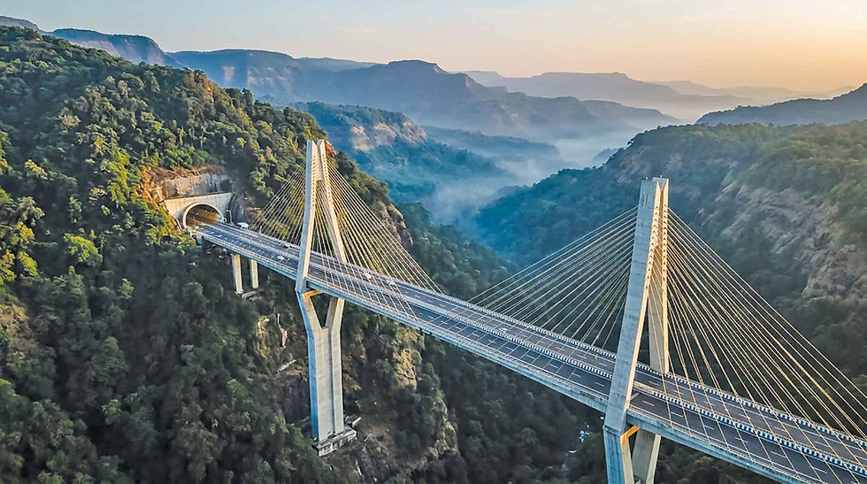
If one structure captures the drama of the Missing Link project, it is the cable-stayed viaduct spanning Tiger Valley.
Rising nearly 182 metres above the valley floor, the bridge demanded engineering solutions more commonly associated with some of the world’s most challenging mountain infrastructure projects. Yet the greatest obstacle at the outset was not technical. It was psychological.
“Nobody wanted to work at those heights initially,” recalls Rajesh Patil.
Workers had to be lifted in suspended baskets high above the valley. Strong winds frequently caused the platforms to sway. Looking down revealed a sheer drop into the gorge below. Fear became a constant companion.
“There was always fear because the lifting systems or motors could fail,” Patil says. “While being lifted upward, you could directly see the deep valley below.”
At the time, many of the sophisticated monitoring and safety technologies now common on large infrastructure projects were either unavailable or far less developed. For workers operating hundreds of feet above the valley floor, the risks felt immediate and personal. Some chose to leave the project altogether.
The challenge was not merely to build a bridge. It was to persuade people that the bridge could be built safely.
Project leaders responded not through motivational speeches but by sharing the risks themselves. Senior engineers increasingly joined difficult site inspections and ventured into areas that others were reluctant to enter. Gradually, confidence spread through the workforce.
“When others saw us taking the risks ourselves, engineers, managers and technical staff also gained confidence and started joining us,” Patil recalls.
He says the team often drew inspiration from Maharashtra’s history, particularly the achievements of Chhatrapati Shivaji Maharaj, who built and maintained hill forts across similarly forbidding terrain centuries before the arrival of modern machinery.
For engineers from Afcons Infrastructure, Tiger Valley soon became the defining technical challenge of the project.
The site combined almost every difficulty that mountain construction can present. The pylons had to rise from narrow ridgelines overlooking a deep gorge. Wind conditions could change dramatically within minutes. What began as a calm morning could quickly become a hazardous work environment.
According to Project Director Ranjan Mishra, gusts could approach 100 kilometres an hour. During the monsoon, dense fog often reduced visibility to a few metres while sheets of rain transformed access routes into logistical nightmares.
“During monsoon, visibility would collapse due to fog and cascading rainwater,” he says.
Conventional construction techniques quickly reached their limits.
The breakthrough came when engineers abandoned traditional high-access methods in favour of highly modular systems. Self-climbing shuttering enabled pylons to rise progressively without extensive external scaffolding. Tower cranes were synchronised to operate safely at extreme heights. Heavy cantilever form travellers allowed bridge segments to be constructed in balanced stages over the valley.
The project also increasingly relied on real-time monitoring. Wind sensors, precision surveying equipment and micro-weather planning became part of everyday decision-making. Construction schedules were often dictated not by weeks or days but by short windows of favourable conditions.
“In terrain like Tiger Valley, engineering calculations alone are not enough,” Mishra says. “Execution windows are sometimes measured in minutes.”
The result was more than a bridge. It was a demonstration of how modern engineering increasingly depends on the integration of technology, logistics and human judgement as much as on concrete and steel.
Yet even as one team battled gravity and weather above ground, another was confronting an equally formidable challenge beneath it. Deep inside the Sahyadris, engineers were attempting something no less ambitious: driving tunnels through uncertain geology beneath a lake and alongside one of India’s busiest expressways.
The Invisible Mountain

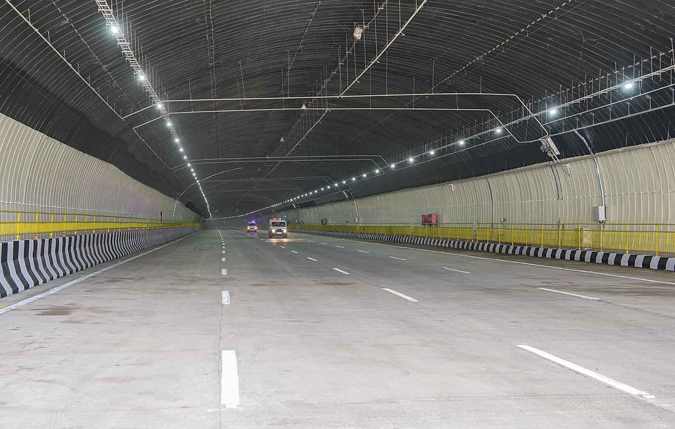
The most remarkable engineering achievement of the Missing Link may be the one most travellers never see. Beneath the Sahyadris, engineers excavated twin tunnels through highly unpredictable basalt formations, passing beneath Lonavala Lake and close to the operational Mumbai–Pune Expressway itself.
The geology was rarely cooperative as stable rock could abruptly give way to fractured zones, weathered strata or water-bearing seams. Conditions changed continuously as excavation advanced. Engineers therefore adopted the New Austrian Tunnelling Method (NATM), which allows support systems to be adjusted according to actual ground behaviour rather than rigid assumptions made before excavation begins.
For Navayuga Engineering, responsible for major tunnelling works, managing groundwater and unstable geology became a daily challenge.
Digital tools played a crucial role. Engineers created a sophisticated digital twin using 5D Building Information Modelling, integrating geotechnical data, structural design and traffic planning into a single platform. Fibre-optic sensors and monitoring systems were embedded within the infrastructure to track long-term performance.
Yet perhaps the most important design philosophy was one largely invisible to the public. The tunnels were designed not simply to carry traffic but to manage failure.
According to project leaders, the greatest risks in modern tunnels are rarely structural collapses. More likely scenarios include vehicle fires, smoke propagation, hazardous cargo incidents and multi-vehicle collisions.
That reality shaped every aspect of the design. Cross-passages connect the twin tunnels every 300 metres, allowing evacuation during emergencies. Ventilation systems can shift into smoke-control mode. Emergency communication systems, surveillance networks and centralised traffic management platforms create what engineers describe as an actively managed transport environment rather than a passive structure.
The tunnel effectively becomes a machine for preserving life during a crisis. Such thinking reflects a broader lesson from the Missing Link. The project succeeded only when engineers stopped treating roads, bridges, tunnels, drainage systems and safety mechanisms as separate disciplines.
Instead, they approached the corridor as a single operational ecosystem where the geology influenced structures, which in turn influenced drainage, which in turn influenced tunnel safety. Tunnel safety then influenced traffic operations. The mountains, thus forced a wholesome integration. And that is the lesson that may ultimately prove more important than the minutes motorists save.
The Missing Link is expected to improve freight reliability, reduce accident risks and strengthen economic links between Mumbai, Pune, Nashik and the industrial clusters emerging across western Maharashtra. Logistics operators value predictability as much as speed as eliminating disruptions along the ghat section could have economic effects far beyond the highway itself.
Yet the project’s true legacy may lie elsewhere. If travellers cross the Sahyadris for decades without noticing the rock bolts hidden behind tunnel linings, the drainage systems buried beneath slopes, the sensors monitoring ground movement or the emergency systems waiting silently in reserve, the engineers involved will regard that as success.
Infrastructure is often judged by what people see. The Missing Link may be remembered for what people never have to think about: accidents that do not happen, delays that never occur and dangers that are quietly designed out of existence.
In that sense, the project is an attempt to make one of India’s most unpredictable landscapes behave predictably. That, in modern infrastructure, is often the highest achievement of all.


Comments